When new faces step off the plane in Kenya, or even after a few days exploring, a common thought settles in: getting around here is going to drain my wallet. Most visitors only ever encounter one slice of the transport pie – the comfortable, often air-conditioned world of taxis, the easy predictability of ride-hailing apps, or the seamless efficiency of a pre-booked private transfer. It feels like the only way, and the cost quickly adds up. Every trip across town, every journey to a new district, seems to carry a hefty price tag, reinforcing this idea that Kenyan travel must be an expensive affair.
But the actual pulse of Kenya, the real movement of its people, beats to a very different rhythm. Beneath that polished surface of convenient private transport, an entire, intricate network hums with life. It’s a vast web of matatu routes, not exactly hidden away in secret tunnels or veiled by magic, but rather operating in plain sight, understood intimately by anyone who calls this place home. Locals rely on these routes every single day, navigating cities and towns with a speed, efficiency, and affordability that astonishes once you learn how it works. These aren’t routes found on a tourist map or neatly cataloged in a global positioning system; they’re an organic, living system. You don’t truly grasp them until you’ve spent time here, observing, asking, and traveling alongside the people who use them as their daily lifeline. Once you unlock this understanding, the cost of moving through Kenya can plummet, often by more than sixty percent.
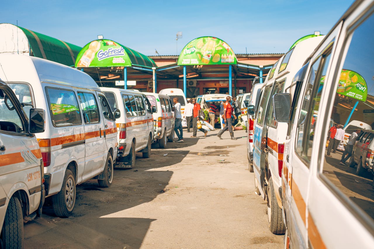
This insight isn’t about finding illicit routes or shadowy connections; it’s about peeling back the layers of local knowledge. To truly understand this, you have to realize that matatus in Kenya are far from random vehicles hurtling around. They operate with the precision and interconnectedness of a complex network, built around distinct stages and corridors. Each matatu is assigned a fixed route, a designated path it follows from start to finish. Along this path, it adheres to specific pickup and drop-off points, known affectionately as ‘stages.’ These routes, in turn, fall within larger transport corridors that act as major arteries for the flow of traffic and people. Even if not officially published, there’s a widely understood, if sometimes informal, pricing structure for each segment of a journey.
Consider Nairobi, for example. The city’s transport system isn’t just a jumble of roads; it’s largely organized around several key corridors. Think of Thika Road, a bustling artery stretching north; Jogoo Road, slicing through the vibrant Eastlands; Ngong Road, leading out to the green hills; Mombasa Road, connecting the city to its industrial heart and beyond; and Waiyaki Way, guiding traffic west. Each of these corridors isn’t just a road; it’s a living conduit, linking multiple estates and smaller towns, forming the very backbone of daily movement for millions. A matatu running on Thika Road, for instance, won’t just take you from the CBD to Thika town; it will stop at Pangani, Roysambu, Kasarani, Githurai, Ruiru – each a stage, each a point of connection.
When people speak of “secret matatu routes,” it isn’t a whisper about anything illegal or illicit. Instead, it’s a nod to a sophisticated system of indirect connections, of lesser-known combinations of stages, of clever shortcuts that link one estate directly to another without passing through the city centre, or junction-based transfers where you hop from one matatu to another to bridge a gap. They are the low-traffic alternative routes, the paths less obvious to an uninitiated eye, but utterly vital to daily commuters. These routes are the domain of locals, seasoned drivers, and regular passengers. You won’t find them on Google Maps, and they aren’t explained in tourist brochures. Their greatest appeal is straightforward: they offer significantly cheaper options than any direct private transport.
Let’s look at a couple of examples within Nairobi itself. Most visitors instinctively assume that any journey across different parts of the city must involve a trip through the Central Business District (CBD). That’s not always the case, and locals know it. Imagine needing to go from Kasarani to Westlands. A tourist might take a taxi directly, or go to Kasarani to CBD, then CBD to Westlands. A local, however, might opt for Kasarani to Roysambu, then transfer onto another matatu that follows the Ruaraka to Westlands corridor. This indirect path often saves both money and time, especially when the CBD is choked with traffic. Similarly, moving from Umoja to an area along Ngong Road wouldn’t necessarily mean a forced march through the CBD. Instead, a local might take a matatu from Umoja to Donholm, then another linking to Pipeline, and from there, catch a matatu that connects directly to the Ngong Road corridor. These overlapping networks, while not always advertised as a single, direct journey, function seamlessly through coordinated transfers.
The “secret” knowledge extends beyond just city estates, reaching out to surrounding towns. Take a journey from Nairobi to Thika. A tourist might look for a single, long-distance matatu or a taxi. But a local might break it down: Nairobi CBD to Roysambu, then Roysambu to Ruiru, and finally Ruiru to Thika. Each segment is a short, affordable hop. This strategy offers more flexibility in terms of boarding points and can often reduce the overall fare. The same principle applies to places like Machakos or Kitengela. Instead of expensive direct taxis, a savvy traveler might go from Nairobi to Athi River, and then Athi River to Kitengela, leveraging the efficiency of public transport for a fraction of the cost of a private ride.
So, why do these efficient, cost-saving routes remain largely “hidden” from tourists? Several factors contribute to this. Firstly, there’s the language barrier. Matatu routes and stages are often communicated informally, using local Swahili slang or nicknames that are unfamiliar to outsiders. A conductor might shout “Gari ya town!” or refer to a stage by a local landmark, making it hard for a non-local to follow. Secondly, there’s a distinct lack of fixed online mapping. Unlike the digitized, neatly cataloged systems of ride-hailing apps, matatu routes exist more as shared community knowledge than as precise digital data points. You can’t simply type in a destination and get a matatu route. Finally, tourist behaviour plays a significant role. Visitors, often on a tight schedule or simply seeking comfort, tend to gravitate towards direct rides, fixed prices, and a certain level of predictability, prioritizing convenience over the optimization that comes with local knowledge. Locals, on the other hand, prioritize the cheapest route, are comfortable with flexible transfers, and are experts at navigating the stage-based movement system.
My own method for uncovering these cheaper routes isn’t reliant on apps or online searches. It’s far simpler, rooted in observation and direct interaction. The first step is always to ask the stage conductor. At every matatu stage, you’ll find drivers and conductors who possess an encyclopaedic knowledge of all connections, big and small. The key phrase to learn is “Wapi gari ya…?” which translates to “Where is the vehicle to…?” This simple question opens doors. Beyond asking, I spend time observing the local movement patterns. Where people queue, where they alight, which matatus they board – these visual cues tell you everything you need to know about the flow of traffic and connections. And crucially, I never commit to an unknown long route immediately. Instead, I test small segments first, building up confidence and understanding before tackling a more complex journey.
The financial advantage of using these routes is striking. Imagine a journey from Nairobi CBD to Westlands. A direct taxi ride could cost anywhere from KSh 300 to KSh 800, depending on traffic and the time of day. But by using the matatu system, breaking the journey into segments, you might pay KSh 30-70 for the first leg to an intermediate stage, and another KSh 30-70 for the second leg to Westlands. Your total cost could be as low as KSh 60 or up to KSh 140. That’s a saving of up to eighty percent – a substantial difference over the course of a trip.
To truly grasp these nuances, you need to shift your perspective from individual journeys to the larger corridor system that defines Nairobi’s transport. The city isn’t just a random collection of streets; it’s a network of major transport corridors that link estates, suburbs, and satellite towns in a structured way. Once you understand the function of these corridors, you can navigate almost anywhere affordably, without constantly reaching for a taxi or ride-hailing app.
The Thika Road Corridor, for instance, is one of Kenya’s busiest. It connects the Nairobi CBD to Pangani, Roysambu, Kasarani, Githurai, Ruiru, and all the way to Thika. Locals don’t think of this as one long, expensive ride, but rather as a chain of short, incredibly affordable hops. You might take a matatu from the CBD to Roysambu, then another from Roysambu to Githurai, and a final one from Githurai to Ruiru. Each segment is cheap, and sometimes, surprisingly, it’s faster than waiting for a direct matatu that covers the entire long route.
The Ngong Road Corridor serves a similar purpose, linking the CBD to Upper Hill, Kilimani, Adams Arcade, and eventually Ngong Town. Tourists often find themselves overpaying for taxis along this route, unaware that matatus operate continuously and efficiently. A key understanding here is the role of specific stopping points, like Adams Arcade, which functions as a crucial transfer hub, allowing for cheaper onward movement further down the corridor.
The Jogoo Road Corridor is the main artery for travel within Nairobi’s populous Eastlands. It connects the CBD to areas like Donholm, Umoja, Buruburu and provides crucial links to the Outer Ring Road. Locals expertly use this corridor to move across vast stretches of Eastlands without the repeated hassle and cost of entering and exiting the CBD.
Then there’s the Mombasa Road Corridor, the primary highway that ties the CBD to the Industrial Area, South B, South C, and extends out to Athi River and Kitengela. Rather than opting for expensive taxis to reach industrial zones or airport areas, the matatus along this corridor offer remarkably cheap and consistent movement options.
Airports are often where travellers first fall into the trap of overspending. At Jomo Kenyatta International Airport (JKIA), most visitors immediately grab a taxi from the designated pickup zones, paying a premium for the convenience. Locals, however, employ a different strategy. They move slightly away from the immediate airport influence zone, often walking a short distance to connect with nearby matatu points along Mombasa Road. From there, they continue their journey into the CBD using standard, low-fare routes. This simple act of bypassing the “tourist exit trap” can dramatically reduce the cost compared to a direct airport taxi. Instead of paying inflated rates, you quickly merge into the normal matatu pricing structure. A similar approach applies at Mombasa Moi International Airport. Rather than private transfers, savvy travellers connect to local matatu routes heading towards Likoni or the CBD, opting for shared transport systems which immediately halve, or more than halve, travel costs.
Even Coastal Kenya, with its distinct atmosphere, adheres to the same principle of route-based matatu movement. In Mombasa and the surrounding areas, the Likoni Ferry acts as a vital connection point, with many routes specifically timed around its operations. Shared minibuses are the dominant form of inner-city movement. Tourists frequently pay more because they lean heavily on private tuk-tuks or taxis. Locals, meanwhile, seamlessly combine ferry rides with matatu connections, navigating shared routes through Likoni and utilising stage-based boarding systems. For example, a journey from Mombasa CBD to Ukunda via the Likoni Ferry and shared matatus is substantially more economical than any direct private transfer.
Most overcharging isn’t the result of deliberate manipulation; it’s a consequence of perception and a lack of local knowledge. The airport arrival pricing trap is a prime example: first impressions often come with a higher price tag. Then there’s the “convenience bias,” where tourists mistakenly assume that direct transport is always better, when in Kenya, direct often equates to more expensive. A lack of awareness about where matatus actually board – the ‘stages’ – pushes many into unnecessary taxi usage. And finally, failing to simply ask locals for the standard fare, a common practice here, often leads to unknowingly overpaying.
Let’s break down a real scenario: moving from Kasarani to Westlands in Nairobi without needing an expensive CBD taxi. Instead of a single, direct ride or a costly taxi, you’d begin by taking a matatu from Kasarani to Roysambu, which might cost KSh 30-50. From Roysambu, you’d then connect to another matatu along the Westlands corridor, for another KSh 50-100. Your total outlay would be a mere KSh 80-150. Compare that to a taxi fare for the same journey, which could easily range from KSh 500 to KSh 900. That difference truly highlights the power of route knowledge.
While it might seem complicated from an outside perspective, locals embrace these indirect routes for three fundamental reasons. Firstly, cost efficiency is paramount; splitting journeys into segments is almost invariably cheaper. Secondly, there’s immense flexibility; you can change your mind or your direction anytime you need to. And thirdly, availability is key; matatus are far more frequent and accessible on these shorter, segmented routes.
These so-called “secret matatu routes” in Kenya aren’t actually secret in any mysterious sense. They are simply the unwritten, highly efficient systems built on shared local knowledge. Once you begin to understand the concept of corridors, the function of stages, and the logic of connection points, navigating Kenya becomes dramatically more affordable and far more efficient. Instead of simply paying for immediate convenience, you start to strategise your movement, and that’s precisely where the real savings begin to materialise. Whether you’re making your way across Nairobi, travelling between distant towns, or exploring the unique coastal regions of Kenya, understanding these matatu networks allows you to move with the ease and authenticity of a local, not just as a visitor passing through. This ability to explore Kenya smarter, cheaper, and with a deeper connection to its pulse, truly becomes your greatest travel advantage.
Discover more from Time to Travel
Subscribe to get the latest posts sent to your email.